


From the Archives
From the Archives – Whose Map Is It? New Mapping by Artists
Today from our archives we bring you Kelly Nosari’s assessment of Whose Map Is It? at the Institute of International Visual Arts in London. Considering the wars currently being waged over land in Palestine, the Ukraine, Syria, and South Sudan (to name just a few), it is interesting to note how artists approach the representation of territory. This article was originally published on July 8, 2010.

Bouchra Khalili. Mapping Journey #1, 2008; film still. Courtesy of galerieofmarseille. Produced with the support of Artschool Palestine.
While the act of mapping conveys authority—giving credence to that which it records—mapping cannot remain entirely static and must be revised to represent changes in power structures. In efforts to better understand or better represent the world, many contemporary artists eschew two-dimensional map making in favor of addressing the ways in which traditional maps are transgressed by global complexities.
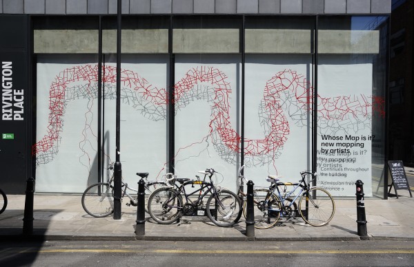
Whose Map Is It? New Mapping by Artists, currently on view at the Institute of International Visual Arts in London (Iniva), offers creative alternatives to a stale representation of global organization. Capitalizing on the potentially transformative nature of mapping, nine contemporary artists deconstruct conventions in favor of introducing previously “off the map” concepts. Whose Map Is It? is inextricably engaged with the larger theme of globalization for the way that this present condition problematizes the traditional two-dimensional nation-state map structure. Presenting new and recent work in diverse media, the exhibition offers freshly layered, content-wise approaches that creatively reposition map making to more fully represent today’s mobile world.

Milena Bonilla. Variations on a Homogenous Landscape (detail), 2006. Courtesy the Artist.
The deconstruction of existing map structures is central to the exhibition. In Milena Bonilla’s Variations on a Homogeneous Landscape (2006), traditional scientific cartographic means are questioned by presenting repositioned and disoriented fragments of familiar maps. In a different vein, Bouchra Khalili’s Mapping Journey films the marking through and across of a two-dimensional map in order to illustrate a path of actual, experienced migration. As the moving image overrides the flat, two-dimensional map, the viewer sees that mobility has become the new global landscape as it crosses political boundaries. Also mapping in an innovative way, Gayle Chong Kwan’s new commission Save the Last Dance for Me charts the movement and migration of rumba. The resulting large-scale, global cultural map is accompanied by a sound piece offering rumba dance instruction.

Oraib Toukan. The New(er) Middle East, 2007; installation view. Photo: Thierry Bal.
Map structures take on postcolonial concepts in Emma Wolukau-Wanambwa’s new commission A Continuing Survey of Syntactic Parsing. In this work, Wolukau-Wanambwa charts British colonial conquest narratives in juxtaposition with bourgeois British civilian life of the same period. Also of postcolonial theme, Alexandra Handal’s Labyrinth of Remains and Migration (2000–01 & 2010) draws visually spare “mental maps” that represent Palestinian dispossession.
The gallery audience is charged with mapping their own Middle East in Oraib Toukan’s interactive magnetic puzzle piece titled The New(er) Middle East. This work references the region’s divisive geopolitical history that has been marked by Western intervention. More specifically, Toukan’s work playfully alludes to the catchphrase introduced by the Bush administration’s Condoleezza Rice in 2006 conceptualizing a more stable Middle Eastern political map through further Western interference and map restructuring.

Esther Polak. NomadicMILK, 2010; installation view. Photo: Thierry Bal.
Globalization’s free-trade economics define the ever-more global face of the world and are therefore addressed by multiple artists in this exhibition. Artist Susan Stockwell’s site-specific commission, River of Blood, focuses on the world’s growing urban populations by highlighting economic disparity in London along a commonly recognized North-South divide. River of Blood is on one hand a map of the Thames River and its tributaries. On the other hand, its red vinyl cut-outs resemble human arteries, thereby emphasizing the visceral socio-economic, geographic divide between the haves (of North London) and have-nots (of South London).
Esther Polak’s NomadicMILK (2009) is engaged with mapping the movements of a particular contemporary economic system. This work tracks the movements of nomadic Fulani herdsmen and dairy transporters throughout Nigeria using GPS technology to illustrate the constant movement required to execute the work of a single industry. Focusing on a site of dramatic economic transformation, Otobong Nkanga’s Delta Stories (05/06) illustrates the ecological ramifications of harvesting oil repositories in a Nigerian delta region.
Susan Stockwell. River of Blood, 2010.Photo: Thierry Bal.
Whose Map Is It? New Mapping by Artists was initiated by Iniva curators Christine Takengny and Teresa Cisneros in conjunction with a full schedule of educational events including the Crossing Boundaries symposium that took place on June 2, 2010.
Whose Map Is It? New Mapping by Artists is on view at Iniva’s Rivington Place in London through July 24, 2010.